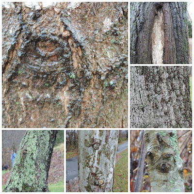
Between the stomach bug and Thanksgiving, we didn't make it to the park last week. However, we did make it there twice this week. So I am counting one of our days for last week.
Week 5 ~ We decided to focus on the many different types of bark for our first nature walk this week. It is amazing all of the different varieties. We found barks that were rough, smooth, peeling, dark, light, and white.
We saw lots of lichen growing on several trees and I will be adding that to our list of things to learn about this year. We were able to identify a few trees by their bark. Some are very obvious like the River Birch pictured below.
 |
River Birch
|
We also noticed that many of the trees in one area were all leaning in the same direction. We wondered if they had all been pushed almost over in the great flood of 1916. As I mentioned before, we are doing our study this year in a flood plain and we know this entire area was under water (rushing water) during that flood. We will have to figure out how to age a variety of living trees to determine if they are really that old. It seems unlikely, but if not the flood, then what calamity made them all bend and then grow in the same direction?
The rain was really picking up and I was worried about the camera so we checked the river depth (a visual check) and headed back to the car. The river was near it's banks and moving at a quick speed.
Week 6 ~ After two more days of steady rain, the river overflowed its banks. We had to head out and see how our urban study area was doing. Our urban study area is in a park on one side of the river and a road and industrial area on the other side of the river. The park was still accessible and we took a few quick pictures. The pictures below were taken at almost the same place as the one above with Dean in it. As you can see the trees that are usually on the edge of the river are in the river.
A little farther down we took a picture of the bridge that crosses the river and leads into the park. This underneath area is where homeless people often sleep. As you can see, it was almost hitting the bottom side of the bridge. We missed the shot, but an entire tree went by while we were standing there.
Next, we decided to explore the road opposite the park and the quarter mile or so farther down river from the park that often floods first. Sure enough the river was completely over its banks on one side of the river and flood waters were covering the road. We had to cross the river to the road on the other side of the river because the police had blocked the road.
 |
| Water is on the road on the other side of the river. |
 |
| Crossing the river on the bridge. The water is almost touching the bottom of the bridge. |
This is not extreme flooding for our area. This is pretty typical and happens a few times a year. It can be much worse and has flooded out the buildings in the pictures a few times since we have lived here. We were here in 2004 which was considered a 100 year flood, and the worst flood recorded for our area was in 1916.
 |
| 2004 |
 |
| 1916 |
Disclaimer ~ We used lots of caution in approaching the river. We used the zoom function on our camera and were not as close as some of the pictures suggest. In fact, several pictures were taken from the car. We never crossed any police lines. Use all caution when dealing with a raging river and flooded roads. Never drive through flood water.
Blessings, Dawn


